On the BBC’s old General Overseas Service, every news bulletin began the same way. Twenty-eight seconds before the hour: ‘This is London’. Next, the jaunty tune we call ‘Lilliburlero’. Five seconds before the hour: the six pips—the Greenwich time signal. The time would then be given in 24 hour clock, Greenwich Mean Time, and the studio cued to start the BBC World Service news programme.
This was the time signature of the British Empire: for an Anglo-colonial living in Northern Rhodesia in 1950, or wherever or whenever, the present instant bore a single, one-to-one correspondence to the London ‘now’; the BBC Overseas Service recognised them both, and maintained the relationship between you and GMT faithfully and reliably. You knew where, not to say when, you stood.
Anybody in regular communication with someone who lives in a different time zone will testify to the strangeness of Skyping not only across space but across time, into a different ‘now’. Talking face to face with the dark while you are in the light is an experience of profound asynchrony, an experience of simultaneous non-simultaneity. The FaceTime is out of joint.
These feelings stem from fundamentally contemporary experiences: they are the result of cheap travel and free telephony’s flinging of us out of time, through space. Jetlag, too, is asynchrony incarnate, the unpleasant somatic repercussion of moving ‘unnaturally’ fast through space, into the wrong time. They reveal the old BBC ‘now’ to have been an illusion. Time-zone difference is natural; the sun sets at a different time across the world. The way we deal with that phenomenon – the way we map time – is not.
The BBC’s Greenwich Mean Time is essentially – although not to a fraction of a second – the same as Coordinated Universal Time (UTC), the primary standard by which the world sets clocks and calculates time. Greenwich Mean Time is what it is, and the world coordinates around it, because of agreements made at the International Meridian Conference of 1884. As Adam Barrows puts it in The Cosmic Time of Empire (2011), this was a very serious moment in the history of modernity, providing ‘a global grid whereby the minutest spatial unit and the most infinitesimal duration of time could be measured in relation to Greenwich, England’. The conference was held, however, in Washington D.C.
The meeting was the brainchild of a very hardworking individual named Sandford Fleming. Fleming was born in Kirkcaldy in 1827, across the Forth from Edinburgh. He started studying under an engineer aged 14, and at 17 emigrated to Upper Canada with his brother. There, he qualified as an engineer and rapidly became a seriously industrious industrialist, producing the first maps of his adoptive town, Peterborough, and running enormous expansions of the railways. He founded the Royal Canadian Institute and designed the Threepenny Beaver, a postage stamp with a beaver on it. He always suggested using iron instead of wood, so that things couldn’t burn down. In 1885 he was responsible for the final connecting part of the line that linked the Pacific and the Atlantic. Sandford Fleming liked to connect what hadn’t previously been connected.
Trains and clocks have a fairly storied association. Airports are full of blinking digital time-telling screens, but the great train stations are old enough that gigantic clocks loom over all of them. Think of Waterloo’s majestic four-faced clock, hanging down the centre of the concourse like a big benevolent spider, or the great towering beauties of the Gare de Lyon in Paris and the Hamburg Hauptbahnhof.
How do you make the trains run on time? Thinking about it hard is a good start. All that frenzied work on railways planted a seed in Fleming’s mind. He decided to universalise time-keeping, and started to harass the world about it. Adam Barrows quotes him as saying that uniform civil time reckoning would be a ‘cosmopolitan’ system benefiting not only ‘men of business’ but also the ‘entire family of man’.
Fleming devised a conference to debate the regulation of time, the reckoning of longitude, and the adoption of a prime meridian. This latter measurement is the line connecting points of equivalent longitude that defines longitude’s zero degree. That line covers half the world, pole to pole. The world is round and thus is wrapped in 360° of longitude: on the other side of the world, the zero degree loops into the 180°.
In order to understand why this has anything to do with Universal Coordinated Time, we have to see how longitude and time have always been inextricably bound up with one another. The story lies in the place after which the prime meridian was named at that conference: Greenwich. The Royal Observatory there was founded by King Charles II in 1675 to solve the serious problem of how to measure longitude at sea by observing the heavens. The problem with longitude is that, unlike latitude, you can’t figure it out by looking at the sky.
As Dava Sobel explains in Longitude (1993), ‘The Equator marked the zero-degree parallel of latitude for Ptolemy. He did not choose it arbitrarily but took it on higher authority from his predecessors, who had derived it from nature while observing the motions of the heavenly bodies. The sun, moon, and planets pass almost directly overhead at the Equator’. The case is the same for the tropics of Cancer and Capricorn, which are determined by the sun.
By contrast, Ptolemy could put his prime meridian, the zero-degree longitude line, wherever he liked. This difference made finding latitude fairly easy, but made the determination of longitude, especially at sea, into a problem that nobody seemed able to solve. Columbus could sail a straight parallel according to latitude pretty easily, but he couldn’t turn corners.
What Columbus needed was a clock that worked at sea. If you want to figure out longitude while on a boat, you need to know what time it is on your boat but also the time at the place you sailed from. You need to figure out the spatial information contained in that time difference: because it takes 24 hours for the Earth to revolve completely, each hour is 1/24th of a 360° revolution. Fifteen degrees of longitude east or west, in other words. If you have both times, all you have to do is set the clock on your boat according to the noonday sun. Every hour of difference between you and the home-time is another 15 degrees. Conveniently enough, 15 degrees of longitude at the equator is 1,000 miles. That distance of course changes as you go up or down the world: but the time difference stays the same.
The real problem was the difficulty of making a precision instrument work well on a boat. Pendulums, for example, do not like constant rocking motions. For proper navigation of the world’s seas, somebody needed to invent a better clock. For lack of good timekeeping, hundreds of British sailors used to die in single shipwrecks when they foundered on the Scilly Isles approaching the south-west coast of Britain. In 1714 the British Parliament passed the Longitude Act, which established a huge reward for the person who could come up with a ‘Practicable and Useful’ means of determining longitude. That man was John Harrison.
Harrison was an English clockmaker, who devoted his life to the project of developing the science of portable precision timekeeping. And he achieved it: Harrison invented the marine chronometer, although it took him a long time and didn’t make him terribly popular. Harrison’s first really successful marine chronometer, the H4, was small: about 13cm across. It looks pretty much exactly like a pocket watch. Harrison’s great idea was that earlier chronometers were too big: the bar balances inside them were affected too much by the ship’s unpredictable rocking.
Before the marine chronometer, everybody – Magellan, Drake, Balboa – just sailed straight and crossed their fingers. The famous ones are the guys who got lucky. They could use dead reckoning, of course: contemporary dead reckoning is a sophisticated process, but back then it just meant throwing a log in the sea and trying to adjust for currents by looking at how quickly and in what direction it was getting away from you.
Having to follow predetermined shipping lanes to keep from getting lost makes you very vulnerable to piracy, aside from everything else. In the light of all these problems, the early phase of European exploration and colonialism seems crazily hubristic. Simply setting off in a boat was in itself madly dangerous – but the great mariners didn’t seem to care.
By the 1880s, of course, the world was everybody’s oyster. Sandford Fleming had hoped that the prime meridian would automatically become the standard of a new Universal Day, where time zones would be coordinated from a defined starting point – the prime meridian. This suggestion was met with considerable anger by delegates at the conference who had neither expected the issues to be conflated, nor all been invested with power by the nations they represented to vote on matters of time. This was a radical moment: nobody had really suggested standard time seriously before.
A eurocentric and universalised time standard was highly controversial among the delegates. For example, Barrows quotes the representative for the Ottoman Empire as arguing that ‘the majority of our population is agricultural, working in the fields, and prefer to count to sunset; besides, the hours for the Moslem prayers are counted from sundown to sundown’. What could a straight line running through London have to do with the temporally-inflected religious cultures of other countries?
For the conference delegates, the problem of time regulation was so thorny that they mostly concentrated on the feasible project of the prime meridian. In a very loosely worded, non-committal document that notionally joined the Universal Day to the prime meridian conceptually, however, the conference delegates signed Greenwich Mean Time into existence. Barrows says that it happened almost by accident. By 1920, the last abstaining countries (notably Turkey) had acknowledged a system of time zones based on GMT as the Universal Day.
Greenwich Mean Time didn’t come out of any top-down dictum from Queen Victoria, or transparent mutual agreement between the world’s nations, but Fleming’s sleight of hand. It was about money. Barrows describes ‘transnational investors who used (or misused) the [conference] … to synchronize countries to precisely coordinated capital flow’. The campaign for a standard time was initiated by American and Canadian engineers. The ruling class in England didn’t seem terribly interested.
As United States delegate Mr W. F. Allen said at the conference, ‘Exactness of time reckoning is an imperative necessity in the conduct of business’. As the railways expanded and businessmen exported goods across great distances, Universal Time came to be required as a commercial tool. But Universal Time also synced the world’s markets together, greatly advancing the connectivity and thus sophistication of international commerce. The conference is a milestone in the history of globalised capital.
Functionally, Universal Time ended up doing something of the same work as the British Empire. The pre-chronometer chaos contrasted strikingly with the later British industrial mania for precision and productivity: think of the clock looming over the factory floor. Timekeeping was put to use in the colonial context as a weapon, in the form of new clocktowers in old towns, or plantation bells controlling the movements of the workers. In the most brutally Benthamite fashion, technologies of time not only facilitated the movement of Europe outside of Europe, as it were, but also functioned as a tool of oppressive social engineering.
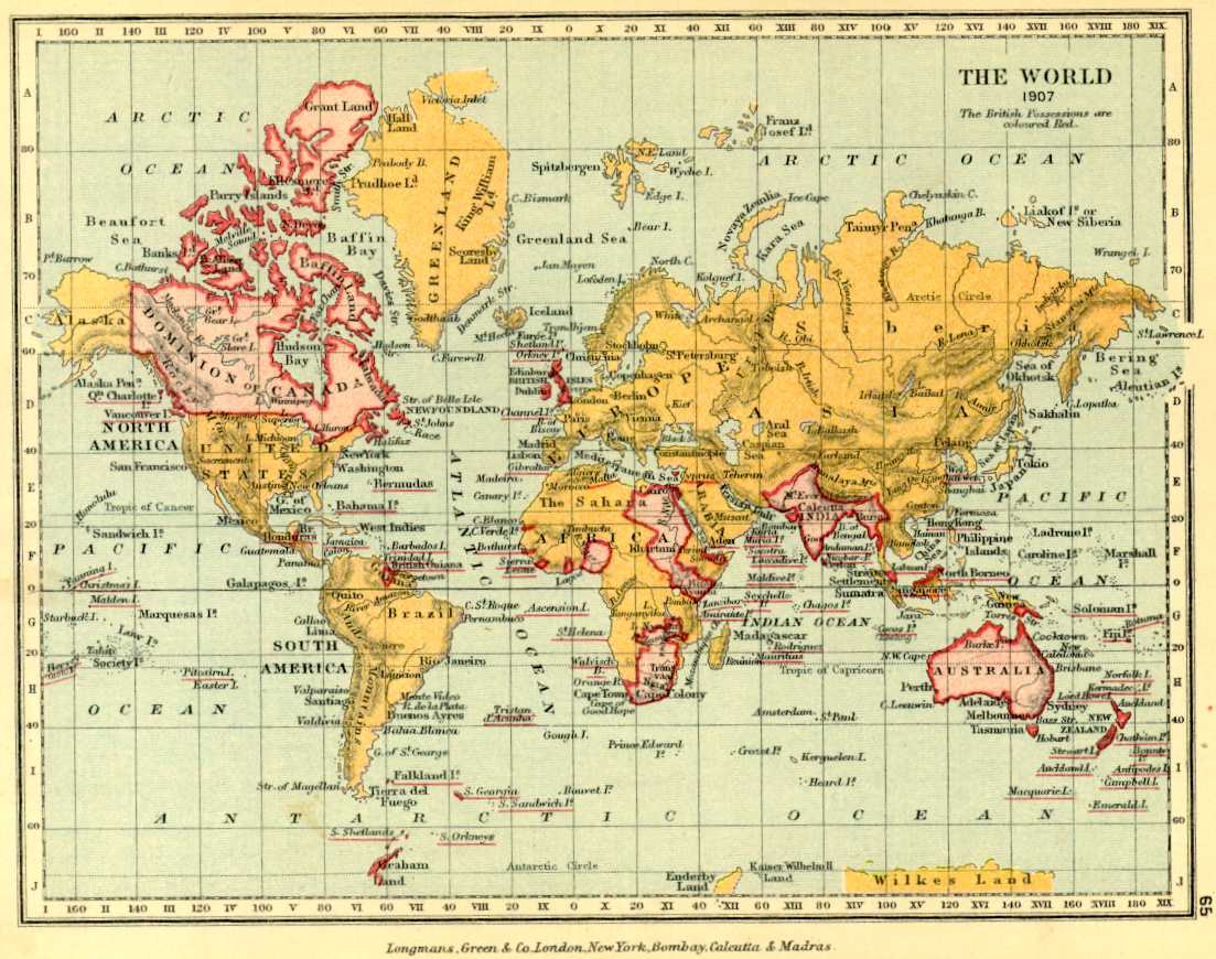
Here, we come back to the BBC and its unflagging, precise broadcasting of those six pips that kept the empire in step with ‘real’ time. The global vision of time regulated by the BBC World Service – the world map coloured pink – is no more. This is not to say, however, that the global vision of time today is an unmediated one, or that nobody has any power over it.
The mapping technology that we carry around in our iPhones and Blackberries was developed by the U.S. military between 1973 and 1994. It was deployed and tested in the First Gulf War. As the Department of Defense reported to Congress in 1992, it was very helpful. The U.S. military granted civilian use of the Global Positioning System (GPS) in 1983, but the civilian signal was kept at a much lower level of accuracy, and only entered the commercial sphere in the Clinton administration.
Even now, the U.S. military restricts civilian use of GPS: all super-powerful receivers are classified as munitions. The U.S. military has a pretty big monopoly on finding things. The technology of mapping time and space, just as it was in 1884, is a form of knowledge that entails a great deal of power. Sandford Fleming’s conference did legitimise the carving up of the globe’s surface into a system whose zero was London; but it happened almost by accident, amid international indignation, in order to sync up the commercial networks that would become today’s globalised markets. While screen GPS feels more objective, less ideological, than the map coloured in pink, it is truly the Royal Observatory, Greenwich’s inheritor. Mapping is a form of knowledge bound up with the flow of capital, the exertion of military might and the threat of implicit violence. In some ways, geopolitics and chronopolitics are the very same thing.
To comment on an article in The Junket, please write to comment@thejunket.org; all comments will be considered for publication on the letters page of the subsequent issue.